Fact Sheets And Publications
Basic Tips for Using the Web Soil Survey to Retrieve Information for Nutrient Management Planning
The USDA-NRCS has created the Web Soil Survey (WSS) as a clearance house for soil survey data from the Soil Survey Geographic Database (SSURGO). Currently, there are data available for almost all counties in the U.S. The WSS can be used to access county specific information about local soils including soil properties and suitability for various land uses (e.g., irrigation, cropping systems, wastewater disposal, septic systems, and construction).
The purpose of this fact sheet is to facilitate use of the WSS to identify soil series in Delaware. This information can be used to identify soil properties that are important for nutrient management planning and cropping (e.g., depth to seasonal high water table, Revised Universal Soil Loss Equation (RUSLE) erosion factors, yield estimates by soil productivity class). More comprehensive instructions for using the WSS are available via the WSS website.
Below, we provide step-by-step instructions on how to locate your area of interest (AOI) and obtain soil map unit descriptions/data including “depth to water table” and “yields of irrigated crops” for your selected area. Lastly, we describe how to export and save reports.
Basic Instructions for Using the WSS
1. The WSS is located at http://websoilsurvey.nrcs.usda.gov (Figure 1). The WSS is best accessed using Microsoft Internet Explorer to ensure full functionality; however, other web browsers may also work adequately.
- Click on the green “Start WSS” button.

2. The WSS starts on the “Area of Interest (AOI)” tab (Figure 2). There are several options for selecting an AOI using the quick navigation header (located in the left hand toolbar).
- Follow these steps to retrieve information on all soils in a county:
a. click on “Soil Survey Area”,
b. select “Delaware” and then your county, and
c. click “Set AOI”.

The selected AOI, the soil survey area in this case, will be outlined in blue (Figure 3).

- Follow these steps to set the AOI for a specific address:
a. Type the address under the “Address” tab.
b. Once the address is located on the map, you can zoom in or out using the tools on the map view (magnifying glasses with + or -) and pan by using the hand tool to get to the correct land parcel.
c. Once you have the map location correct, you can select the desired area using the AOI tools in the map (circled in red) (Figure 4). There are two AOI selection tools, one for rectangular shaped (left) and one for customized shapes (right).

3. Once an AOI is selected, click on the “Soil Map” tab to open the soil map view (Figure 5). The orange outlines on the map depict the individual soil map unit boundaries. Each map unit is assigned a map unit symbol, which is defined in the map unit legend (located on the left). The legend shows the map unit name (based on the predominant soil series), the acres of that map unit in the AOI, and the percentage of the AOI covered by that map unit.

4. More information about the soil map units within the AOI is available under the “Soil Data Explorer” tab. There are many types of data available via the “Soil Data Explorer” tab.
Here are some examples of the data you can obtain:
Soil Map Unit Descriptions provide more detailed information about the soil series included in a soil map unit (Figure 6).
- Follow these steps for information on the dominant and minor soil series:
a. select the “Soil Reports” tab,
b. click to expand AOI Inventory,
c. choose “Map Unit Descriptions” from the menu on the left, and
d. click on “View Soil Report”.

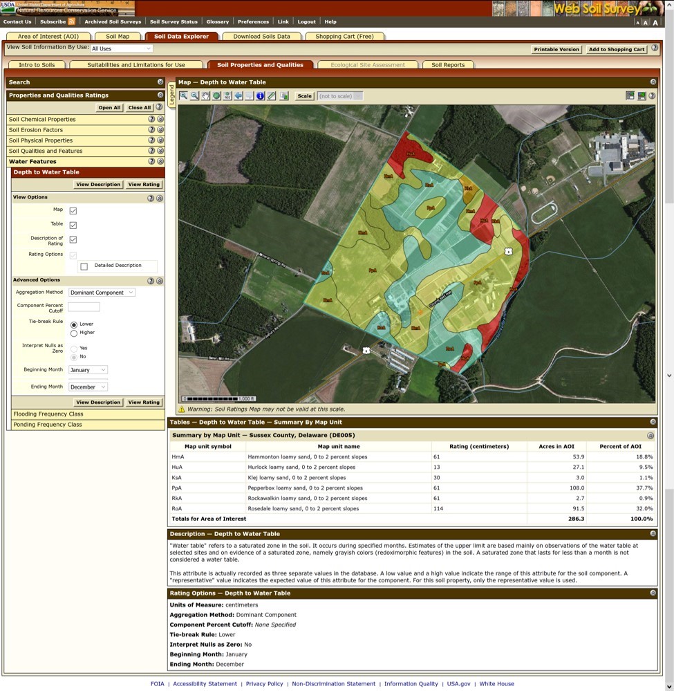
Depth to Water Table provides an estimation of the depth below ground surface to the seasonal high water table (Figure 7).
- Follow these steps to access “Depth to Water Table”:
a. select the “Soil Properties” tab,
b. choose “Water Features” on the left menu,
c. click “Depth to Water Table”, and
d. choose “View Rating”.

Yields of Irrigated Crops provides the information from the soil productivity charts (Figure 8). This information is useful for estimating yield goal in Delaware in the absence of actual yield data.
- Follow these steps to access “Yields of Irrigated Crops”:
a. select the “Vegetative Productivity for Use” tab,
b. select “Yields of Irrigated Crops”, and
c. select “View Report”

5. Export reports by clicking on “Add to Shopping Cart” in the upper right corner as you select data. You can then navigate to the “Shopping Cart” tab.
Summary
These preliminary instructions will help consultants and farmers start using the Web Soil Survey to retrieve information from the NRCS SSURGO databases. More comprehensive instructions for using the WSS are available via the WSS website.
UD Cooperative Extension
This institution is an equal opportunity provider.
In accordance with Federal law and U.S. Department of Agriculture policy, Cooperative Extension is prohibited from discriminating on the basis of race, color, national origin, sex, age, or disability.
